Tapering for a big effort can be so hard to judge, being theoretically simple but practically affected by other (external/immutable) factors. So how do you score that two-day D of E expedition (Wednesday/Thursday) from Corrour to Kinloch in a ‘tapering’ context, being low-intensity but significant time-on-feet when tapering should maybe be more about maintaining the intensity and reducing the volume? (The answer after some thought in my case being to almost dismiss the c.18 miles of walking involved and head back out after a couple of hours’ break for a proper wee 7.9-mile burn up to Tigh-na-sleubhaich and back in the hope of salvaging about 30 of the 35–40 miles of running I’d have had down for this week without the exped… although whether the trade-off should be scored on quite those terms is anyone’s guess!)
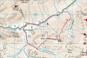
Fancied a short but interesting hill run today to keep on track for said 30-mile target, and that’s exactly what I got this afternoon with a 6.7 mile/2,600 ft traverse of Beinn Mhic Chasgaig in Glen Etive (a proper west coast hill where last weekend’s trip to Ben Wyvis was more akin to a run through a 3,000 ft high ‘park’!). So I crossed the single-plank bridge at the bottom of the Allt Coire Ghiubhasan and turned from one gorge to another to follow the bouldery gully of Coire Aiteil before taking the northerly ridge off for the stunning prospect of Stob Dearg ahead, but ultimately couldn’t give that much attention to the view as I found myself having to pick my dizzily undernourished way down with some care (not to mention craving for the banana I’d left in the van for my return)! Happy with the taper, however (need 5 or 6 miles tomorrow then another big mileage cut to a 15–20 mile ‘week’ with some rest over the final few days), feeling strong (maybe in the best shape I’ve ever been for this kind of thing) and hoping everything’s coming together just right for something special in Saturday’s 95-mile monster…


Is that bridge over the river near Alltchaorunn still blocked by a hefty barbed wire gate?
And how was your re-crossing over the river further upstream on your return journey?
I’m hoping to do this hill in the near future; it would be helpful to have some up to date info.
Cheers
Murdo
Comment by Murdo — 11 June 2011 @ 10:46 pm
Gate’s still there (and shut), but wasn’t locked… suspect this is normal because they’re obviously expecting folk on the hill (notices further up saying please take the path round because access rights don’t extend to the cottage garden), but can’t promise! Also a ‘beware of the labrador’ sign on the cottage gate, but I’d already sussed out that I’d have to go round (NB there’s a stile back over the deer fence at about the ‘A’ of ‘Altchaorunn’) to avoid any invasion of privacy. Path’s quite wet and potentially slippy with plenty of flat, slabby rock, but the descent to the single-plank bridge (while straightforward) worth the camera I wasn’t carrying! River crossing was fine, being not quite knee depth tapering to paddling and quite amenable, but has to vary depending on exact location and preceding conditions… although you don’t need to cross back at all up there with the south bank looking a reasonable alternative to the road.
Comment by admin — 12 June 2011 @ 8:45 am
Quote from ‘Corbetteer’ blog [2018 edit: link now dead] found while Googling Beinn Mhic Chasgaig:
‘For many years this heavily fortified gate was locked making access to the east side of the Etive very difficult. New access laws have forced the land owners to remove the padlock and take down some of the barb wire.’
Can’t say whether that’s why or not, but looks increasingly likely that you’ll not find it locked.
Comment by admin — 12 June 2011 @ 2:15 pm
Thanks for those directions Pete. Feeling like I needed to stretch my legs after watching the WHW race action, I decided to go up this hill en route home from Fort Wm on Sunday afternoon. The route I took was pretty similar to your’s (yes, the single plank bridge is interesting). But as I was descending I could see a pull-yourself-across-the-river-Etive in a bucket contraption far down below me, slightly upstream from the bridge @ 220520. As I got closer to this set-up I could see that the wooden steps up to the bucket were rotten / broken / mostly missing. But the bucket and wires were in situ; but the bucket was securely padlocked and unavailable (Not surprisingly, I guess). The choice was to get wet feet (ankles, knees, whatsits ~ depending on where I crossed the river); or try an unsecured wire rope crossing here. I felt a bit like the great tightrope walker Blondin as I eased myself across; and the experience certainly focussed the brain cells to the exclusion of everything else. But I made it. Phew! Dry feet. But if I was in charge of a bunch of school kids I somehow don’t think taking them across would have been approved of…….
It’s a fine hill, and I was lucky to have great weather. The views from the top were panoramically wondrous! Strongly recommend it!
Murdo
Comment by Murdo — 20 June 2011 @ 9:02 pm
Ah yes, Murdo… the ‘Sheep Transporter’ (no kidding when it’s marked as such on the 1:25,000 OS map)! I saw that too, but not the bucket (assumed it was just a slatted bridge missing its slats), so wondering if that’s separating the sheep from the goats here and (if so) who’s the blessed sheep and who’s the damned goat? (Not to mention the vision your ‘pull-yourself’ description conjures up of some baa…d sheep doing just that!)
;-)
Comment by admin — 20 June 2011 @ 9:57 pm